The speed of these routines is greatly improved by switching the screen output OFF in Output Manager.
Extract cross sections along a pre-calculated horizontal alignment.
|
Icon |
Command |
Shortcut Key |
Toolbar |
|
|
TERRAINCROSSEXTRACT |
|
|
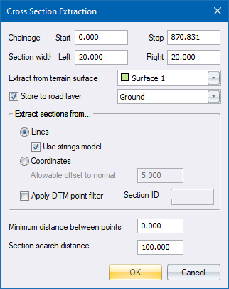
This function allows you to extract cross-sections from ground or design data along a pre-defined route. Therefore, you need to generate a horizontal road alignment before using this function. You can do this using Alignment ► Horizontal in the Road Menu.
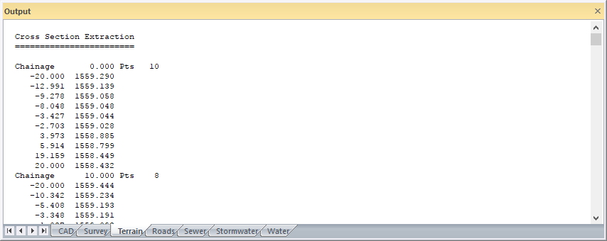
A start and stop chainage must be specified for the extraction of the sections. The chainage values chainage coordinates are retrieved from the current road database. First select the required road if necessary.
The width of the section to the left and right of centreline must be specified. If the extracted cross-section data extends beyond these limits, the cross-section is 'snipped' and an elevation is interpolated at the offset limit.
The search distance is the distance (left and right of the section line) that is scanned for line nodes. The shorter the distance, the less data has to be scanned, and the faster the operation is. There is, however, a minimum distance of 100m that is applied if the entered distances are less than that.
Be careful of specifying a very short search distance. This can result in points being omitted, particularly in the case of design data where lines joining terrace corners are of critical importance but can often be a long way apart. The line might fall within the search radius but the nodes may not, in which case the line is ignored.
A minimum distance between section points can be entered. This is used to filter out redundant data on the sections that are closer together than the specified distance. In areas of critical detail such as existing roads, drains, etc., this value should be set to '0' so all points or line crossings on the section line are adopted.
Sections can be extracted from the lines connecting points, or from the point coordinates directly.
In the case of extraction from lines, you must have previously generated a terrain model using Add Break Line, Add Feature Line, Intelli-Lines or Triangulate. An offset and elevation is added to the section by interpolation at each point where the section crosses a terrain break line. This option is used where sections are required in new and theoretical locations, on a previously surveyed or defined site.
In the case of extracting the sections from coordinates, the offsets and elevations are derived from all points within a specified distance of the section line. All points falling within this "band of interest" are assumed to be part of the section, and their offsets and elevations are added to the file. This option has relevance where sections are surveyed in the field approximately along some physically defined alignment, for example between batter boards during road construction or along a boundary for pipeline design.
A layer in the current road database, must be entered, into which the cross-sections are stored.
You can choose if the extracted cross-sections are stored or viewed, by selecting or de-selecting the Store to road layer option. De-select the Store to road layer option if your cross-sections are to be checked first before storing them. If this has been done previously, and the sections are to be saved, make quite sure that the correct road file is loaded.
The speed of these routines is greatly improved by switching the screen output OFF in Output Manager.
If the first or last section on a run appears misaligned, check that the horizontal alignment in the road database is correct. The direction of each section is derived by comparing the current chainage coordinate with the one before and after it. If one of those is wrong, as a result of a partial recalculation for example, the derived section will be skew. Another possibility is that the section has been deliberately set skew by Edit Chainage Record under Tools in the Road Menu.
Procedure
Fill in the relevant data and click OK.
They are also listed in the Output Bar.