Only points within the current view are operated on.
Automatically generate break and feature lines between points.
|
Icon |
Command |
Shortcut Key |
Toolbar |
|
|
TERRAININTELLILINES |
|
|
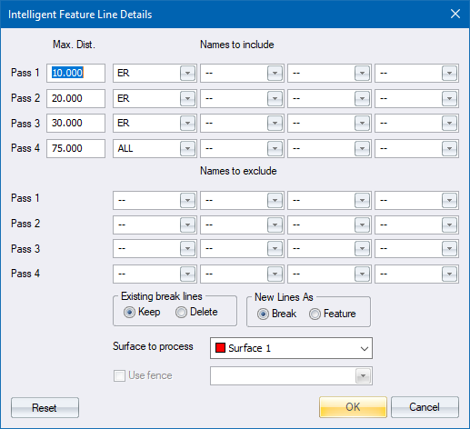
This function allows you to automatically generate break and feature lines between points. The function joins points that lie within a certain proximity of one another, and that pass a name filter. There is no limit on how many times the routine can be run. Either points that are currently visible on the screen or points located within a defined fence are processed.
Each time the routine is run, up to four search distances can be entered to set the maximum distance beyond which no two points can be connected. As a rule of thumb, use the nominal point spacing multiplied by 1.5 or 1.75. For example, if the terrain points are at 20m intervals, try using a search area of 30m or 35m. For ground surfaces, it is better to err on the short side rather than the long. For design surfaces, a long search distance is usually required.
'Spaces' may have been left between spot heights when doing a survey because of inaccessible areas. If your search distance is too short, points cannot be joined across these areas. This can cause problems when generating contours. On the other hand, a long search distance can generate inaccurate contours. Therefore, good judgement is required from the operator.
A name filter and surface must also be specified. This controls the data points that are considered for connection. To consider every point, use the key word 'ALL' in the inclusion filter and 'NONE' in the exclusion filter. The distance specified for the search distance is usually dependent on the criteria in this name filter.
You can select whether to retain or abandon any existing break lines (all feature lines are automatically retained). If existing break line data is retained, no new lines will cross existing lines. This allows you to handle tricky sites by first joining critical areas, such as valley lines, banks and roads, manually or in separate passes; and then connecting the remainder of the site automatically.
The function attempts to link each point to eight other points (one in each octant) within the specified search distance, and without crossing an existing or previously generated line. Lines will not be connected to points on different surfaces, and any points with an elevation of '0' are not considered.
Once lines have been generated, they should be checked to make sure that they are a true reflection of the site (a 3D View can help here). Remember that the idea is to have a system of co-planar polygons that hug the ground surface. Generally, if the lines between the points do this, then the polygons take care of themselves. However, some manual editing is usually required in areas of complicated or man-made terrain.
Run the routine several times if more than one descriptor is to be used. The lines should be generated by specifying the most critical data in the first name filter; followed by less critical data in subsequent filters; and finally a 'mopping up' filter for the remainder of the points.
Only points within the current view are operated on.
Procedure