Extract a long section along a defined alignment (road or pipe bend points).
|
Icon |
Command |
Shortcut Key |
Toolbar |
|
|
TERRAINLONGEXTRACT |
|
|
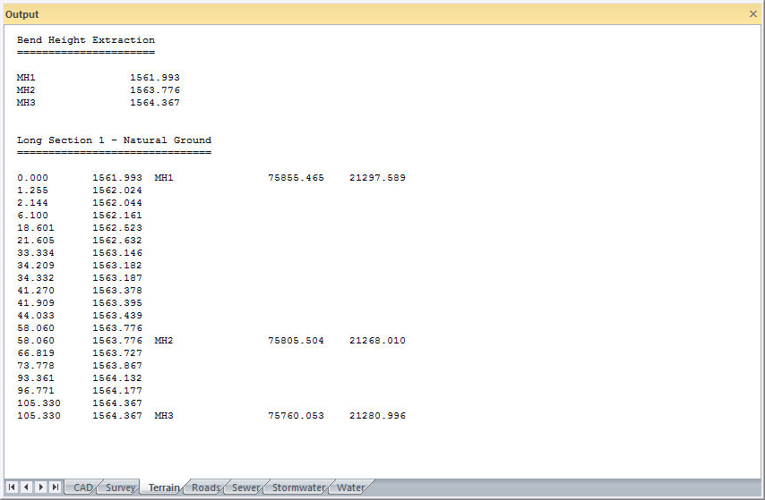
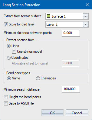
This function allows you to extract long sections from ground or design data, along a pre-defined route. The route the long section takes can be specified by 'bend point' names (e.g. a pipeline), or by chainage points from the road database. Like the Cross-Section functions, the long sections can be extracted from either lines or points.
In the case of extracting the long section from points, an offset from the section line must be entered. This defines a 'band of interest'. All points falling within this band are assumed part of the section, and their offsets and elevations are added to the file.
A minimum distance between successive section points can be entered. This is used to filter out redundant data on the section that are closer together than the specified distance. In areas of critical detail, such as existing roads, drains, etc., this value should be set to '0' so that all points or line crossings on the section line are adopted.
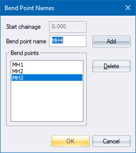
In the case of entering the bend points by name, a list box must be filled with the names of the points defining the route through which the long section should be extracted. There is an option to interpolate a height for the bend points or to leave them as is.
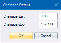
If the route of the long section is to be derived from the chainage points in the road database, you must enter a Start and Stop chainage for the extraction.
The extracted long section can be stored in an ASCII file, or in the currently loaded road file as chainage and centre point elevation. The names, heights and coordinates of the bend points are also stored. This long section can be plotted using the Plot function. If you choose to store the data to the current road file, existing data in that file may be overwritten, and any new data is added to the file. Select a redundant road file if you do not want to keep the output.
The method used for interpolating the heights for the bend points depends on whether the section is being gathered from lines or points.
In the case of a long section from lines, the program first attempts to height all the bend points that do not have a Z value. This is done by extracting a mini cross-section at each bend point, and then interpolating a height from this cross-section.
In the case of a long section from points, the entire long section is extracted and then the elevations of the bend points are determined by interpolation from the long section.
Running chainages are handled differently depending on the long section type:
A section through named bend points will have its chainages related to the straight-line distances between bend points.
A section based on road points will have its chainages adjusted onto the bend points. In other words, between 22400 and 22500 there will be 100m of section regardless of whether the actual straight-line distance is less than this or not.
Procedure
Fill in the relevant data and click OK.
Fill in the relevant data and click OK.
Fill in the relevant data and click OK.
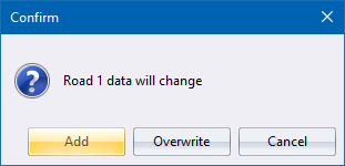
Click Add to have the long section chainages added to the existing chainages in the current road file; click Overwrite to replace the existing long section with new data; or
click Cancel to cancel the function.