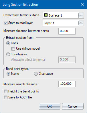
Specify the parameters used to extract a long section.
Option
|
Description |
Extract from terrain surface |
Select the surface from which the long section should be extracted. |
Store to road layer |
Select this checkbox and select a layer in which to store the long section. If this option is not selected, the extracted data is only listed for information purposes. |
Minimum distance between points |
Enter a filter distance to be used to thin out points along the long section. |
Extract section from... |
|
Lines |
Select this option to extract DTM points from line crossings. |
Use strings model |
Select this checkbox to include any crossings with terrain and road strings that are encountered in the long section. This option is disabled if there are no visible road strings or terrain strings to use. |
Coordinates |
Select this option to extract the long section only from nearby DTM points. |
Allowable offset to normal |
DTM points within this offset distance from the long section will be used to extract the long section. |
Bend point types |
|
Name |
Select the Name option to extract the long section along an alignment defined by named points.
|
Chainages |
Select the Chainages option to extract the long section along an alignment defined by the horizontal alignment of the current road file. |
Minimum search distance |
Enter the maximum distance away from the centreline that will be searched for cross-section line crossings or points. Note that the minimum distance is 100m. |
Height the bend points |
Select this checkbox to have the bend points assigned a Z ordinate by interpolation (See the Technical Notes in Long Section for details on how the interpolation is carried out). |
Save to ASCII file |
Select this checkbox to have the long section points written out in comma-delimited format for later import into a spreadsheet or other program. |
OK Button |
Click to accept the current entries in the dialog. |
Cancel Button |
Click to cancel the function. |
See Also Long Section