
Home > Node Data Dialog
Nodes are points of a conveyance system that connect conveyance links together. Nodes are also the points where external inflows can enter a drainage system.
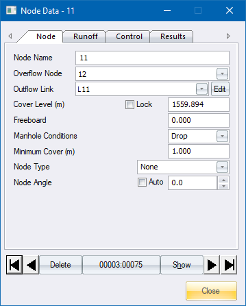
The node data editor allows you to input or edit node and inflow data. It also includes a page which displays the results relating to the node.
Use the arrow buttons to page through the database, or click the record number button to search for a particular node or record number.
Option
|
Description |
Arrow Buttons |
Click the arrow buttons to scroll between the node records. The two outer arrows scroll to the first and last record. |
Delete/Recall Button |
This button marks the current record for deletion, or if it has already been deleted it will remove the deletion flag. Deleted records are only removed from the database when you close the project and answer Yes to the question "Do you want to remove deleted records". Once the database has been packed it is impossible to recover the deleted records. |
Record Number Button |
Click the button that displays the current record number, i.e. the button that displays 00001:00075, to search for a specific record. |
Show Button |
Click to move the mouse cursor to the specific node for that record. The window also automatically zooms into the area around that node. |
Close Button |
Click to close the window. |
Option
|
Description |
Node Name |
The name or reference to this node and outgoing link in up to 25 alpha-numeric characters. Searches can be performed on these names. |
Overflow Node |
The name of the node to which overflows must be directed. This is optional. If no overflow node is specified all overflows will be taken into local storage. |
Outflow Link |
The name of the link that this node discharges into. |
Cover Level (m) |
The level of the node (manhole) cover in metres. |
Lock |
Option to lock the cover level to the specified level. |
Freeboard |
Height that the manhole cover must be above the extracted cover level. |
Manhole Conditions |
The state of the node invert. This may be one of the following settings:
|
Minimum Cover |
The minimum cover to the link at this node. |
Node Type |
Select a manhole type from the list. Manhole types are defined in the Default Settings. |
Node Angle |
Enter the angle in degrees for the node angle or use the arrows to increase/decrease the angle. Positive values rotate the node in a counter-clockwise direction and negative values in a clockwise direction. |
Auto |
Select this checkbox to align the node at the same angle as the outgoing link. |

Option
|
Description |
Subcatchment |
The subcatchment can be selected from a list. The runoff area is then calculated from the subcatchment polygon. The subcatchment option is not active if the area is locked. |
Lock |
Option to lock the runoff area to the specified area value. |
Runoff Area (ha) |
The total contributing runoff area in hectares. The Runoff Area option is not active when a subcatchment is selected, since the area is calculated from the subcatchment polygon. |
Paved Area (%) |
The percentage of the sub-catchment that consists of impervious material. |
Paved Area Entry Time (min) |
The
paved entry time is the time it takes the runoff from the paved
area to run along a gutter with a hydraulic radius of 60mm and
a Manning factor of 0.02 to the inlet. The overland flow time
for the runoff to reach the gutter is assumed to be two minutes,
which is added to the gutter travel time. |
Paved Depression Storage (mm) |
The average losses in millimetres due to surface irregularities in the paved area. |
Supplementary Area (%) |
The percentage of the sub-catchment that consists of impervious material, which discharges onto a permeable surface i.e. roofs that discharge onto a lawn. |
Grassed Entry Time (min) |
The
time, in minutes, for a drop of water to travel from the furthest
part of the grassed zone to a point on the contributing paved
area or to the stormwater inlet if the contributing paved area
is zero. |
Grassed Depression Storage (mm) |
The average losses in mm due to surface irregularities. |
Soil Type |
The soil classification which determines the rate of infiltration. |
Inflow Hydrograph |
The name of the inflow hydrograph file. |

Option
|
Description |
Lock |
Option to lock the runoff area to the specified area value. |
Runoff Area (km2) |
The total contributing runoff area in square kilometres. The Runoff Area option is not active when a subcatchment is selected, since the area is calculated from the subcatchment polygon. |
Subcatchment |
The subcatchment can be selected from a list. The runoff area is then calculated from the subcatchment polygon. The subcatchment option will not be active if the area is locked. |
Time of Concentration (hours) |
The time it takes for a drop of water to travel from the most distant part of the catchment to the catchpit. Click ... to display the Time of Concentration calculator. |
User Specified Point Rainfall |
Select if the Rational Runoff calculations must not calculate the Point Rainfall value from the standard Rational Runoff graphs, but must make use of the entered value. |
Catchment Characteristics |
|
Rural Percentage |
The rural portion of the catchment area expressed as a percentage of the total area. |
Rural Factor |
The rural area runoff coefficient, which can be calculated using the rural coefficient calculator. |
Urban Percentage |
The urban portion of the catchment area expressed as a percentage of the total area. |
Urban Factor |
The urban area runoff coefficient, which can be calculated using the urban coefficient calculator. |
Lakes |
The percentage of the catchment area consisting of lakes or ponds which do not contribute to runoff. |
Inflow Hydrograph |
The name of the inflow hydrograph file. |

Option
|
Description |
Lock |
Option to lock the runoff area to the specified area value. |
Catchment Area (km2) |
The total contributing runoff area in square kilometres. The Runoff Area option is not active when a subcatchment is selected, since the area is calculated from the subcatchment polygon. |
Subcatchment |
The subcatchment can be selected from a list. The runoff area will then be calculated from the subcatchment polygon. The subcatchment option is not active if the area is locked. |
Percentage Impervious Catchment (PIMP) |
The percentage of the catchment area covered by impervious surfaces intended to drain to the storm sewer. |
Time of Entry (min) |
The time it takes for a drop of water to travel from the most distant part of the catchment to the catchpit. Click ... to display the Time of Entry calculator. |
Previous Pipe Length (m) |
The length of pipe between the upstream sub-catchment and this sub-catchment. |
Previous Pipe Velocity |
The calculated flow velocity in the pipe between the upstream sub-catchment and this sub-catchment. |
Time of Flow (min) |
The time of flow through the previous pipe to the point under consideration. Calculated from the pipe length and velocity. |
Time of Concentration |
The time of concentration is equal to the sum of the time of entry and the time of flow. |
Soil Type |
The soil index SOIL is based on the Flood Studies Report and can be obtained from the revised soil map covering the whole of the United Kingdom. The index takes one of the values 0.15, 0.3, 0.4, 0.45, 0.5 according to the five soil types - 1 to 5 respectively. |
Inflow Hydrograph |
The name of the inflow hydrograph file. |

Option
|
Description |
Subcatchment |
Specify which subcatchments drain to this node. Click Edit to open the Subcatchment Editor. |
Inflows |
Displays YES if there are inflows into this node; and NO if there are none. Click ... to display the Inflows Editor. |
Displays YES or NO to indicate if treatment functions have been assigned to this node. Click ... to display the Treatment Editor. |

 In order for this
function to work, a node type must have been selected and the network
must have been analysed.
In order for this
function to work, a node type must have been selected and the network
must have been analysed.
Option
|
Description |
Fixed Invert (m) |
The fixed invert level of this node. |
Maximum Inflow (m3) |
The flow into the link can be limited to a specific value, regardless of the capacity of the link. This can be caused by the size of the inlet structure. |
Maximum Storage (cubic m) |
If no overflow node is specified, the analysis module assumes that excess link flows will be taken up in some form of local storage i.e. a surge tank. In many instances, you want to take a specified volume of flow up in local storage, and then pass the excess flow on to an overflow node. |
Node Y Coordinate |
The Y coordinate of the node or manhole. |
Node X Coordinate |
The X coordinate of the node or manhole. |
Chamber Diameter / Chamber Length |
The internal diameter of a round node's chamber or the internal length of a rectangular node's chamber. |
Chamber Breadth |
Only visible when the shape is rectangular. The internal breadth of the node's chamber. |
Chamber Height |
Maximum for 100 year values. |
Wall Thickness |
The inside height of the main chamber excluding the base. |
Base Thickness |
The wall thickness of the main chamber. |

Option
|
Description |
Node Invert |
The calculated invert level of the node. |
Node Depth |
The calculated difference between the node cover level and the node invert. |
Cover |
The cover to the outgoing link. |
Inflow |
The inflow into the node. |
Overflow |
The overflow from this node to the overflow node (if any). |
This button marks the current record for deletion; or if it has already been deleted it removes the deletion flag. Deleted records are only removed from the database when you close the project and answer Yes to the question "Do you want to remove deleted records". Once the database has been packed it is impossible to recover the deleted records.
Click the button that displays the current record number, i.e. the button that displays 00001:00075, to search for a specific record. After finding the record, click Show to move the mouse cursor to the specific node for that record. The window also automatically zooms into the area around that node.
See Also Node Data