Graphically insert points into the database.
|
Icon |
Command |
Shortcut Key |
Toolbar |
|
|
TERRAININSERTPOINT |
[F5] |
|
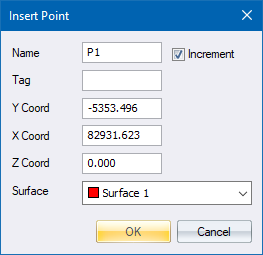
This function allows you to insert points into the database graphically with the mouse. When the mouse is clicked, the point details display with the coordinates. Switching on Snap Mode allows you to snap to the nearest existing point. A name can be entered and a surface to which the point should be assigned must be selected. The Y, X or Z coordinates can be altered if required.
If the Auto Interpolate function is switched on, a height is interpolated for this point from the currently selected surface.
See Also Interpolate Point for situations where one needs to control the surface and points used to define the plane used for interpolation; or where one needs to interpolate points beyond the limits of the reference plane.
This function can also be used for rapidly typing in new coordinates without resorting to the Enter Point function.
Procedure
Indicate insertion point
Fill in the relevant data and click OK.