Home > Project Settings Dialog
Option
|
Description |
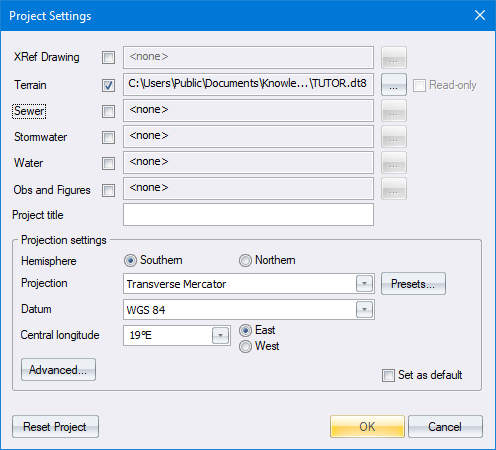
XRef Drawing |
Select the checkbox and click ... to define a background drawing filename and path. |
Terrain |
Select the checkbox and click ... to define the DTM filename and path. |
Read only |
Select the checkbox if you want the DTM and all the roads in a project to be treated as read only. |
Sewer |
Select the checkbox and click ... to define the Sewer filename and path. |
Stormwater |
Select the checkbox and click ... to define the Stormwater filename and path. |
Water |
Select the checkbox and click ... to define the Water filename and path. |
Obs and Figures |
Select the checkbox and click ... to define the Obs and Figures filename and path. |
Project Title |
Enter a description for this project. |
Projection Settings |
|
Hemisphere |
Select either the Southern or Northern hemisphere options to set the hemisphere in which the data is located. |
Projection |
Select the mapping projection to be used. Four projections are available:
Selecting Local will automatically set the Datum to Cape and causes Civil Designer to treat the Terrain and Road database coordinates in the same way as Stardust used to. |
Presets button |
This option provides an alternative to specifying the traditional projection settings. In the Project Presets dialog, you can choose from various preset options that include all the needed projection settings without you knowing the details of them. When you select an option, the Project Settings dialog shows the chosen preset system option instead of the traditional settings. |
Datum |
Select the datum on which the data is to be based. This determines the ellipsoid on which the projection is based, and therefore the constants used for the mapping projection. |
Central Longitude |
Enter the central LO of the panel in which the data falls (actually the longitude on which the 0 value of the horizontal ordinates of the coordinate system falls) and also select whether this LO is East or West of 0ø longitude (Greenwich). |
East / West |
Select whether this LO is East or West of 0ø longitude (Greenwich). |
Advanced |
Displays the Advanced Project Settings. |