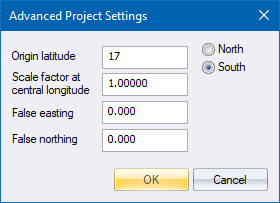
Home > Advanced Project Settings dialog

|
Option
|
Description |
|
Origin Latitude |
Enter the latitude on which the 0 value of the vertical ordinates of the coordinate system falls, and also select whether this latitude is North or South of 0ø latitude (the Equator). This should normally be set to 0ø (origin at the equator where North or South are immaterial) but could be different for some projections. |
|
Scale factor at prime longitude |
Enter the factor by which coordinates are adjusted in order to fit the projection. This should normally be set to 1.0 except if you are using UTM or New Zealand TM coordinates (see Remarks below). |
|
False Easting and False Northing |
Enter the values to be subtracted/added to the LO coordinates during projection conversion. These should normally be set to 0 except if you are using UTM or New Zealand TM coordinates (see below).
Do not use the False Easting and False Northing settings to apply some constant to the data coordinates, as the projection calculations rely on full coordinates and will give incorrect values if these entries are used incorrectly. In this case, you should use Rescale Survey |
In order to use a UTM system, the following settings should be made for Locale:
Convert the UTM block number to LO using the formula (BLOCKNUMBER x 6ø) - 183ø. This calculates the Longitude of the central meridian in degrees.
Set the scale factor at the central meridian to 0.9996.
Enter the correct False Easting and False Northing values of +500 000m Easting, and 0m Northing for Northern Hemisphere or +10 000 000m Northing for Southern Hemisphere.
The New Zealand Transverse Mercator is a specific setup of UTM. By selecting the New Zealand TM option the other options are automatically set for you.
The datum is set to New Zealand Geodetic Datum 2000 (same as GRS 1980).
Origin Latitude: 0ø S, though 41ø S is occasionally used.
Origin Longitude: 173ø E.
False Northing: 10 000 000m N.
False Easting: 1 600 000m E.
Scale Factor: 0.9996.