Create or edit Land Use objects.
|
Icon |
Command |
Shortcut Key |
Toolbar |
|
|
STORMSWMMLANDUSESDLG |
|
|
Land Uses are categories of development activities, or land surface characteristics assigned to subcatchments. Examples of land use activities are residential, commercial, industrial, and undeveloped. Land surface characteristics might include rooftops, lawns, paved roads, undisturbed soils, etc. Land uses are used solely to account for spatial variation in pollutant buildup and washoff rates within subcatchments.
You have many options for defining land uses and assigning them to subcatchment areas. One approach is to assign a mix of land uses for each subcatchment, which results in all land uses within the subcatchment having the same pervious and impervious characteristics. Another approach is to create subcatchments that have a single land use classification, along with a distinct set of pervious and impervious characteristics that reflects the classification.
Procedure
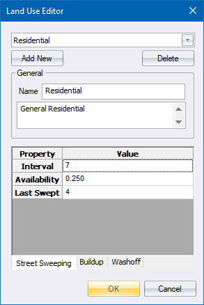
The Land Use Editor displays.

The editor has the following fields plus table entries for each of the three pages.
|
Element
|
Description |
|
Land Use Selector |
Select the Land Use to edit. |
|
Add New |
Click to add a new land use to the project. |
|
Delete |
Click to delete a land use from the project. |
|
Name |
The name assigned to the land use. |
|
Description |
An optional comment or description of the land use. |
|
Tables |
|
|
Street sweeping can be used on each land use category to periodically reduce the accumulated buildup of specific pollutants. |
|
|
Specify the characteristics of the buildup of pollution. |
|
|
Specify the characteristics of the washing off of pollutants. |
|
See Also Subcatchments