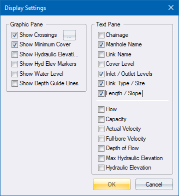
Home > Vertical Alignment Editor - Display Settings

Items that will be displayed on the longsection.
|
Option
|
Description |
|
Crossings |
Display services that cross this pipe. The services can be selected using the Crossing Services window, which is displayed when this option is selected. |
|
Minimum Cover |
Display the minimum cover line. |
|
Hydraulic Elevation |
Display a solid line indicating the total hydraulic energy elevation. |
|
Hyd Elev Markers |
Display indicators in the nodes indicating the total hydraulic energy elevation. |
|
Water Level |
Display the water level in the culverts. |
|
Depth Guide Lines |
Display the minimum and maximum depth guide lines. |
Items that will be displayed in the information block at the bottom of the long section.
|
Option
|
Description |
|
Chainage |
Display the chainage measured from the start of the branch. |
|
Manhole Name |
Display the node name at each node. |
|
Link Name |
Display the link name between nodes. |
|
Cover Level |
Display the node cover level at nodes. |
|
Inlet/Outlet Levels |
Display the inlet and outlet levels at nodes. The level of the incoming culvert will be on the left and the level of the outgoing culvert on the right of the node marker. |
|
Link Type/Size |
Display the link type and size between nodes. |
|
Length/Slope |
Display the link length and slope between nodes. |
|
Flow |
Display the calculated flow through the link. |
|
Capacity |
Display the capacity of the link. |
|
Actual Velocity |
Display the actual flow velocity of the link. |
|
Full-bore Velocity |
Display the velocity if the link is at full-bore. |
|
Depth of Flow |
Display the depth of flow in the link. |
|
Max Hydraulic Elevation |
Display the value of the maximum hydraulic elevation. |
|
Hydraulic Elevation |
Display the value of the total hydraulic energy elevation. |