Icon
Command
Menu
Toolbar
![]()
TK_SURVEYTRAVERSE
Toolkit
Survey COGO
Add point by entering distance and angle.
|
Icon |
Command |
Menu |
Toolbar |
|
|
TK_SURVEYTRAVERSE |
Toolkit |
Survey COGO |
This function allows you to reduce a conventional simple traverse, in which it is assumed that all distance reductions have been carried out separately, and that the distances supplied have been reduced to the horizontal. Therefore, it does not require the entry of the vertical angles.
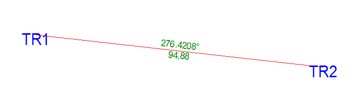
In the example below, the Traverse leg TR1 to TR2 has the distance 94.88m and bearing 276.4208ř.
Procedure
The drawing must be in Surveyor Mode, or the program displays the following message and exits from the function.
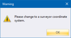
If the drawing is not in Surveyor Mode, you can change the coordinate system in Drawing Settings.
Click on the setup station.

Click Yes to accept automatic naming of each leg of the traverse viz TR1,TR2; or click No if you want to give each leg of the traverse a different name.


Accept the start number "1" to be added to the base name, or enter your own.


Click Yes if you want survey dimensions between points.

Enter the flat distance of the horizontal leg of the traverse.
