Icon
Command
Menu
Toolbar
![]()
TK_SURVEYTACHESHOT
Toolkit
Survey COGO
Reduce tachy shots for a field station.
|
Icon |
Command |
Menu |
Toolbar |
|
|
TK_SURVEYTACHESHOT |
Toolkit |
Survey COGO |
This function allows you to calculate new points from the tache shots of a simple tache survey. It is assumed that all distance and bearing reductions have already been performed.
Procedure
The drawing must be in Surveyor Mode. If not, the program displays the following message and exits from the function.
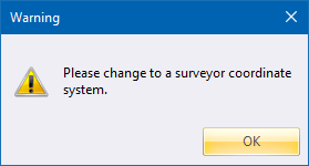
If the drawing is not in Surveyor Mode, you can change the coordinate system in Drawing Settings.
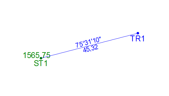
Indicate tachy setup station
Click on the setup station.

Click Yes to accept automatic naming of each leg of the traverse viz TR1,TR2; or click No if you want to give each leg of the traverse a different name.

Input a suitable name and press [Enter].

Accept the start number "1" to be added to the base name, or else enter your own.

Click Yes for lines between the points, or No for just the points.

Click Yes for survey dimensions between the points, or No for just the points.


Enter the bearing of traverse leg.