Icon
Command
Menu
Toolbar
![]()
TK_SURVEYADDPOINT
Toolkit
Survey COGO
Add coordinate point/s to the drawing.
|
Icon |
Command |
Menu |
Toolbar |
|
|
TK_SURVEYADDPOINT |
Toolkit |
Survey COGO |
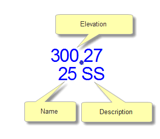
This function allows you to add a coordinate point to the drawing. You can specify the point name, elevation and description. The point has the same format as the import points function, and can therefore be used by the other COGO functions.
In the following example, add a coordinate point to the drawing.
Procedure
The drawing must be in Surveyor Mode, or the program displays the following message and exits the function.
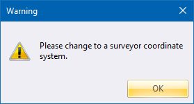
If the drawing is not in Surveyor Mode, you can change the coordinate system in Drawing Settings.
Indicate position of point
Indicate the position where you want the point to be placed. You can use any of the snap or jump modes to position the cursor accurately.

Enter the point name, or leave a blank and press [Enter] to exit this function.

Enter the elevation, or leave a blank for no elevation.

Enter the point description, or leave a blank for no point.
 You can add an elevation and description at any stage by changing the properties of the COGO point.