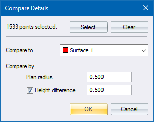
List coordinate and elevation differences between points with a certain radius.
|
Icon |
Command |
Shortcut Key |
Toolbar |
|
|
SURVEYSCREEN |
|
|
This function allows you to list the coordinate and elevation differences between any two points that are found within a certain distance of each another, as opposed to the automatic screen option that deletes them.
Compare Co-ordinates ( Plan Radius 0.200 )
==========================================
Name Y X Name DY DX Dist Dz
==== ======== ======== ==== ==== ==== ==== ====
mh3x 3963.384 5588.428 MH3 0.165 0.164 0.197 -0.036
234c 3923.510 5630.500 G24 -0.049 -0.026 0.074 0.040
235c 3967.211 5687.812 G25 -0.002 0.126 0.138 0.008
236c 3975.584 5697.048 G26 0.118 0.051 0.141 -0.036
237c 3874.020 5727.810 G27 0.188 0.041 0.197 -0.019
mtr5 3956.868 5712.303 G28 0.019 -0.970 0.110 0.020
Procedure
In the example above, the following occurs. If there are any points, with any name and on surface "New System", that are within 0.020m in distance AND within 0.1m in height from points specified in the point selection will be listed. The points belonging to Surface 1 are what is listed in the first Name column and coordinate column. The points found on the other surfaces are listed in the second 'Name column' together with the deltas.