Option
|
Description |
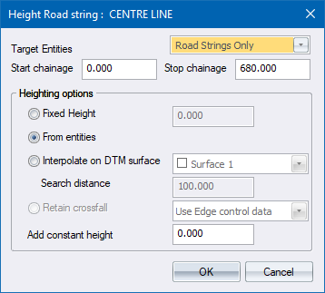
Target Entities |
Specify whether you want to target:
|
Start chainage |
Enter the start chainage for string extraction. Heights will only be extracted from the CAD/Road strings from this chainage. |
Stop chainage |
Enter the stop chainage for string extraction. Heights will only be extracted from the CAD/Road strings up to this chainage. |
Heighting options |
|
Fixed Height |
Select this option to specify a fixed height for the selected road line. |
From CAD entities |
Select this option to extract elevations from 3D CAD entities. |
Interpolate on DTM surface |
Select this option to extract elevations from a DTM surface, usually the survey of an existing road. |
Search distance |
Specify the search distance to find relevant points on the selected DTM surface. |
Retain crossfall |
Select this option to use superelevation data when calculating heights. |
Use Edge control data |
Select this option if you want the superelevation to come from the data in the edge control spreadsheet. The X,Y position of the vertices is extracted from the CAD lines but the Z position is calculated using the Edge Control. In earlier version of Civil Designer, this was the default Retain crossfall option. |
Use current string slopes |
Select this option if you want to extend the selected string to its new position while maintaining the existing slope of each vertex from its parent string. |
Add constant height |
Add a constant to the extracted elevation. For instance, if you want the extracted road line to be 100mm above the existing surface you must specify "0.100". |