Home > SG Diagram Options Dialog

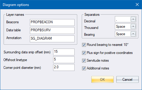
Specify layer names and other options for the SG Diagram.
Option
|
Description |
Layer Names |
|
Beacons |
Specify a layer name for the survey beacons. |
Data table |
Specify a layer name for the data table listing the coordinates. |
Annotation |
Specify a layer name for the annotations on the diagram. |
Surrounding data snip offset |
Specify the offset in mm on paper around the erf figure that is used to clip surrounding data. i.e. everything within this offset gest copied across to the new diagram drawing. |
Offshoot linetype |
Specify the line type to indicate lines that do not belong to the consistency. This value is used by the Adjust Drawing function. |
Corner point diameter |
Enter the diameter for the corner point beacon circles in mm on paper. |
Separators |
Specify the character to be used for the decimal point, the thousands position, and for building up a degree, minutes and seconds bearing value. |
Round bearing to nearest 10" |
Select this checkbox to round bearings to the nearest 10 seconds. |
Plus sign for positive coords |
Select this checkbox for positive coordinates on the diagram prepended with a "+" sign. |
Servitude notes |
Select this checkbox to be prompted, when creating a diagram, to include notes under the Servitude heading specified under the Text tab. |
Additional notes |
Select this checkbox to be prompted, when creating a diagram, to include notes under the Notes heading specified under the Text tab. |