|
Option
|
Description |
|
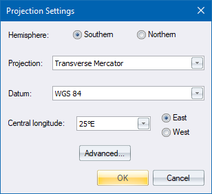
Hemisphere |
Select either the Southern Hemisphere or Northern Hemisphere option to set the hemisphere in which the data is located. |
|
Projection |
Select the mapping projection to be used. Four projections are available, namely Local, Transverse Mercator, UTM (Universal Transverse Mercator) and New Zealand Transverse Mercator. Selecting Local will automatically set the Datum to Cape and causes Civil Designer to treat the Terrain and Road database coordinates in the same way as Stardust used to. |
|
Datum |
Select the datum on which the data is to be based. This determines the ellipsoid on which the projection is based, and therefore the constants used for the mapping projection. |
|
Central Longitude |
Enter the central LO of the panel in which the data falls (actually the longitude on which the 0 value of the horizontal ordinates of the coordinate system falls) and also select whether this LO is East or West of 0° longitude (Greenwich). |
|
East / West |
Select whether this LO is East or West of 0° longitude (Greenwich). |
|
Advanced |
Displays the Advanced Project Settings. |